Do you use a GPS
 When should you use latitude and longitude or grid references for position fixes? Have you ever wondered what all those numbers and letters mean? Read on.
A GPS is a magic tool to help you find your position on earth or to help you navigate your way around the bush. Depending on what you tell your GPS to do, your position can be given in terms of latitude and longitude or as a grid reference. What’s the difference and what should you use?
Geographic Co-ordinates (latitude and longitude)
Lines of latitude are imaginary lines (circles) running parallel to the equator and they indicate the location of a place as so many degrees, minutes, and seconds north or south of the equator. Lines of longitude are imaginary lines (meridians) running from pole to pole and they indicate the location of a place as so many degrees, minutes, and seconds east or west of the prime meridian (O°) which runs north-south through Greenwich in the UK. The conventional method of describing the location of a place using geographic coordinates is to state the latitude first. Thus, the geographic coordinates of Tookeron campsite are expressed as 28° 03’43”S,152°47’54”E. Most GPS will give you the option of expressing geographic coordinates in degrees, minutes and seconds, or degrees and minutes to the nearest 1/1000th of a minute, i.e.28°3.717’S,152°47.900’E. Your choice! By the way, 60 seconds = 1 minute and 60 minutes = 1 degree. And did you know that 1 minute of latitude = 1 nautical mile (1852m). The distance represented by 1 minute of longitude varies because lines of longitude are not parallel.
Grid References
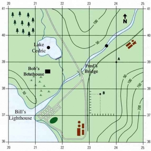
 Topographic maps usually have a pattern of lines running north-wouth and east-west. These grid lines are 1000m apart and they are numbered in the margin, and sometimes within the map area as well. The numbers on the vertical lines increase in magnitude as you read left to right (towards the east). These lines are called eastings. The horizontal lines increase in magnitude as you read bottom to top (towards the north). These lines are called northings. The squares formed on the map can be identified by reference to the numbers on the lines that intersect in the SW corner of the square. Thus, Tookeron campground is located in grid square (GS) 8095. By subdividing the grid square further (lines 100m apart), we can get a more accurate description of the location of the campground as 802959. This is a 6 figure reference . Eight figure grid references (lines 10m apart) are rarely used because of the impracticality of estimating such small distances on maps.
From where to these numbers come? Look at the bottom left corner of any topographic map and you will see that the numbers on the grid lines are part of a larger number. This shows that the grid line (easting) numbered 80 on the Kooralbyn map, is really numbered 480 000m east of somewhere, and the northing numbered 95 is really 6 895 000m north of somewhere. So the “6” figure grid reference (GR) for Tookeron campground becomes 480200 6895900. This looks almost identical to the title of this article. From where does the 56J come?
UTM
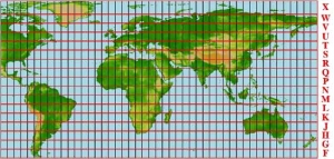
 One method of representing the surface of a sphere on a flat piece of paper involves using a transverse mercator projection. A universal transverse mercator (UTM) map of the world would end up looking like Figure 1. By dividing the circumference of the world (360°) by 60, we end up with 60 zones, each 6° wide. These are numbered 1-60 starting at the 180° meridian (Basically, the international date line). By dividing the area between latitudes 80°S and 80°N into zones 8° wide, we get 20 divisions identified by letters of the alphabet (Reading south to north and omitting A,B,I,O,Y and Z.) Thus, each part of the grid can be identified by reference to these two scales. Look at Figure 1 again and you can see that S-E Queensland lies in 56J.
Let’s go back a few paragraphs. We said Tookeron campground lies 480200m east of somewhere and 6895900m north of somewhere. The”somewhere” is the reference point (false origin) from which the grid lines for each zone are numbered. Figure 2, which is reproduced from “The Lasnguage of Topographic Maps” by Biddle, Milne and Shortle,1974, shows how the zones are created, how the grid lines are formed (using the origin), and how they are numbered (using the false origin).
By combining the zone (56J) with the grid reference, we get a unique combination of numbers and letters for any point on the surface of the earth. This is the format used by a GPS when you tell it to display its position as a grid reference. If you’re lucky, your GPS might even highlight the grid lines by enlarging the two numbers that correspond to the grid lines on your map,e.g. 6895900.
So which should you use? Generally, it is difficult to identify the geographical coordinates of a place on large scale topographic maps. Likewise, it is difficult to identify the grid reference of a place on small scale maps. So it depends on the scale of map you are using. As a general rule, use whatever the map uses. You will probably use latitude and longitude for small scale maps (
Beware
Map makers identify the location of lines of latitude and longitude, and grid lines, by reference to a particular datum. Over the years, those people who control mapping in Australia have used different datum. If you use the wrong datum for the map you are using, the position description given by your GPS will not correspond to the position description shown on the map. This error can be up to about 250m. You will find the map datum printed in the margin of all topographic maps and more and more tourist maps. It will look like AGD66 (or AUS66), AGD84 (or AUS84), WGS84, GDA94, etc. You have to tell your GPS which one to use. Almost all maps based on WGS84 and GDA94 datum will display this on the map. If in doubt, assume AGD66 (or AUS66). And if someone gives you a GPS reference for a particular place, ask them what datum they used. For example, the title of this article was based on AGD66.
